
Drizzlecombe is a complex of Bronze Age monuments located on the western side of Dartmoor in Devon, England. It consists of an extensive group of stone rows, standing stones (menhirs), cairns, as well as enclosed settlement sites which mainly spread across the slopes of Hartor Hill near the River Plym.
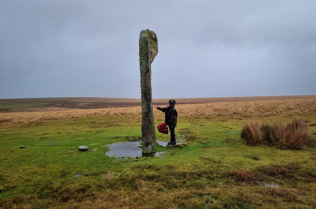
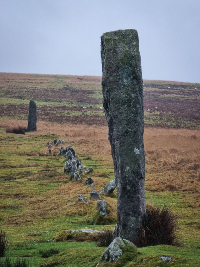
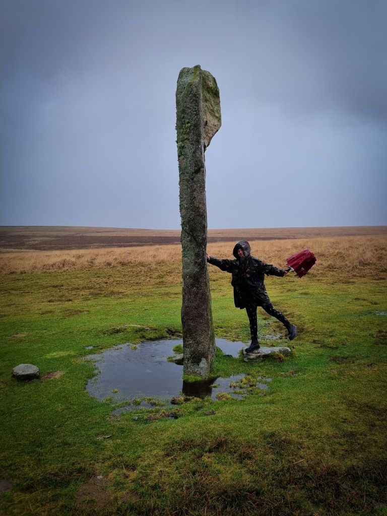
The most striking features of Drizzlecombe are its three stone rows, each with an associated barrow and terminal menhir. The tallest of these menhirs stands at over 4 metres tall. When the complex was surveyed in 1889, it was found that the three menhirs had fallen down. In 1893, Richard Hansford Worth and Sabine Baring-Gould and others re-erected these stones.
The following is quoted from ‘Report and transactions – The Devonshire Association for the Advancement of Science, Literature and Art, Volume 25, 1893’:
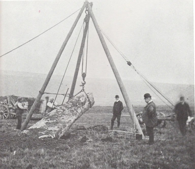
“By permission of Sir Massey Lopes, Bart., I have also been able to re-erect three fine stones, connected with the three interesting stone rows of Drizzlecombe, in the Plym valley. One of these is a splendid stone, measuring eighteen feet in height and from two feet seven inches to three feet eight inches in width. It stands at one end of a stone row, and a cairn surrounded by a double circle of stones at the other. The original hole in which the monolith stood was found. Anciently only about two feet six inches had been buried. This was insufficient, and we sank the original pit, and buried four feet six inches, so that it now stands thirteen feet six inches above the soil. The stones at the end of the other rows measure respectively twelve feet three inches and six feet six inches. They have also been re-erected, sinking each about two feet three inches in the ground.
The re-erection of these fine stones was performed by Messrs. Turpin, of Plymouth, under the supervision of the Rev. S. Baring-Gould, Mr. R. Burnard, and Mr. R. Hansford Worth. (S BARING GOULD).” – https://archive.org/details/reportandtransa10artgoog/page/172/mode/2up
The following is from Worth’s Dartmoor, first published by The Devonshire Association in 1953:
“Drizzlecombe group-
This is the most neatly arranged group on Dartmoor, and, with the possible exception of Merrivale, the sole example which shows what buy our modern standards would be regarded as planning. As it stands it would permit additions which would leave an entirely symmetrical arrangement, and there is at least one indication that such additions may have been contemplated.
The rows are best described by reference to the plan(Fig. 73), and the general position determined by that of Giants Basin shown on the plan, which is, Devon, 6 inch O.S., cxii, SE., lon. 3°-59′-6″, lat. 50°-29′-5″. It may be noted that the contour of the pound which lies just south-west of the large cairn at the north-east extreme of the group, and has two hut-circles within it is shown a little too regular ; its correct contour can be seen in Fig. 32,p. 136. For present purposes the matter is unimportant. [See also the note appended to the legend.]…
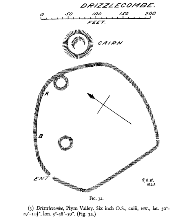
…It will be seen that the abreast of A on the plan is a standing stone. If a line be drawn from this stone to the north-westernmost of the three barrows below the pound, one then has a completely symmetrical collection of rows, and this may have been contemplated.
In this group we have three rows, each terminating at its north-east end in a barrow, and its south-west end in a menhir ; rows perfect and strictly defined ; with the aid of the plan it will not be necessary to do more than give their respective detail.
Drizzlecombe Group (A)
A Barrow, uncircled, 18ft in diameter, at the north-east end; at the south-west end a menhir, 12ft 6in. in length as fallen, 10ft 6in high as erected. Length of row 488ft, direction of length N. 47°-30′ E. The row is in part double, in part single, and it is doubtful whether it was ever wholly double.
Drizzlecombe Group (B)
A circled barrow, 29ft in diameter at the north-east end; and a menhir 9ft 5in. in length as fallen, 7ft 9in. in height as erected, at the south-west end. Length of row 491 ft, direction of length N. 50°-30′ E. The row is single throughout except for one pair of stones next the menhir.
Drizzlecombe Group (C)
A circled barrow, 34ft in diameter, at the north-east end ; and at the south-west a menhir, 17ft 10 in. in length as fallen, 14ft in height as erected. The row is single throughout, and the stones are more widely spaced than in either of the other rows. Length of row 276ft direction of length N. 44° E…
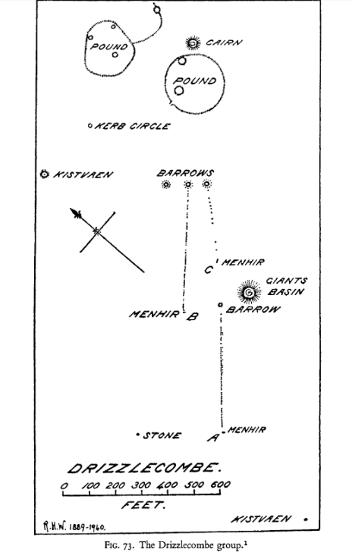
…It will be noticed that row B points to the cairn at the top of the plan ; and that there is another alignment in this group, not a row, marked out by three graves, namely the kistvaen in the bottom right-hand corner, the cairn known as Giants Basin, and the cairn at the top of the plan.
There are shown on this plan, two large cairns, four barrows, two kistvaens, and a kerb retaining circle around an interment pit. There are also two pounds and six hut-circles. It would not appear that the living were anxious to remove their dead to a distance, as has so often been suggested, or perhaps I should say asserted.
The elevation of the ground at Giants Basin is approximately 1,100 ft; and its gradient, falling from north-east to south-west is approximately 1 in 22. This is one of the few groups in which all parts can be seen from all parts, and perhaps this has had an influence on its symmetry.” – https://devonassoc.org.uk/devoninfo/worths-dartmoor-the-stone-rows-of-dartmoor/

Leave a comment