
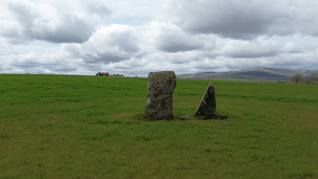
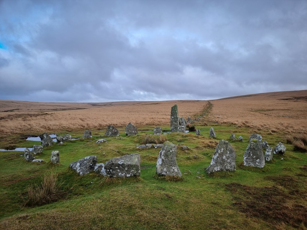
Meini Gwyr.. situated in Glandy Cross in Carmarthenshire, straddling the Pembrokeshire boundary..

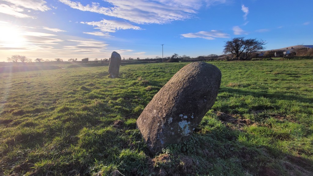
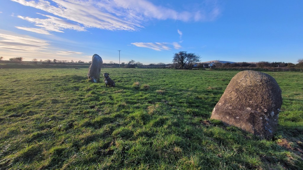
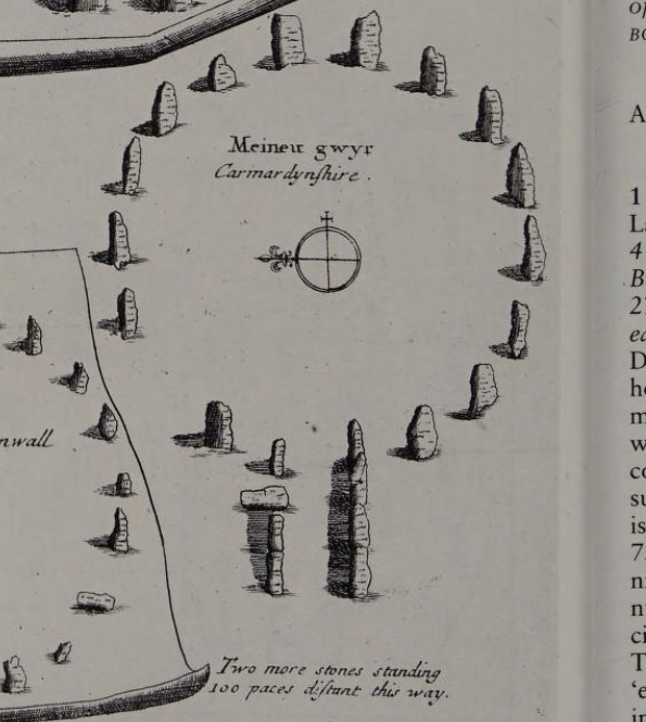
Today, all that remains of this monument, estimated to be from the Bronze Age, is a few lonely stones. In the 17th Century Edward Lhuyd recorded that there were still fifteen stones in the circle, and he was aware that some stones had already been ‘carried away’..
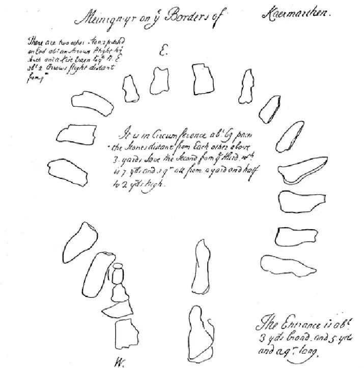
Printed in Edmund Gibson’s edition of Camden’s Britannia in 1695, Edward Lhuyd’s account ran:
“But Buarth Arthur or Meini Gwyr, on a Mountain near Kil y man Llwyd, is one of that kind of circular Stone-monuments which our English historians ascribe to the Danes. The Diameter of the Circle is about twenty yards. The stones are as rude as may be, and pitch’d on end at uncertain distances from each other, some at three or four foot, but others about two yards; and are also of several heights, some being about three or four foot high, and others five or six. There are now standing here, fifteen of them; but there seem, to be seven or eight carry’d off.
The entry into it for about the space of three yards, is guarded on each side with stones much lower and less than those of the circle, and pitch’d so close as to be contiguous. And over-against this avenue, at the distance of about two hundred paces, there stand on end three other large rude stones, which I therefore note particularly, because there are also four or five stones erected at such a distance from that circular monument which they call King’s Stone near Little Rolrich in Oxfordshire.
As for the name Bruarth Arthur,[in a later publication this was corrected to Buarth]it is only a nick-name of the vulgar, whose humour it is, though not so much (as some have imagin’d) out of ignorance and credulity, as a kind of Rustick diversion, to dedicate many unaccountable Monuments to the memory of that Hero; calling some stones of several tun weight his Coits, others his Tables, Chairs, etc. But Meini Gwyr is so old a name, that it seems scarce intelligible. Meineu is indeed our common word for large stones; but gwyr in the present British [Welsh] Signifies only crooked, which is scarce applicable to these stones, unless we should suppose them to be so denominated, because some of them are at present upright, but a little inclining. It may be, such as take these circular Monuments for Druid-Temples may imagine them so call’d from bowing as having been places of worship.(Gibson 1695, cols 628–9; cf. RCAM 1917, 111, fn.)”
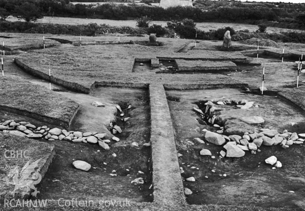
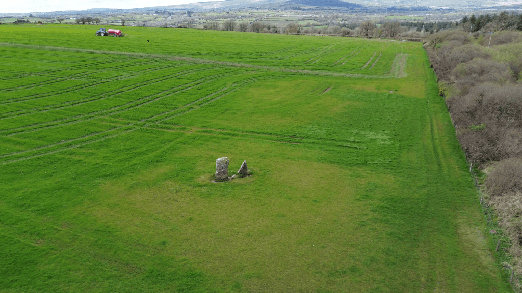
Its structure and history are still probably best understood from the 1938 excavation, which proved that the two orthostats lying c. 6.5 metres apart within the bank on its south are all that remain of some 17 (or more) stones making up the original circle.
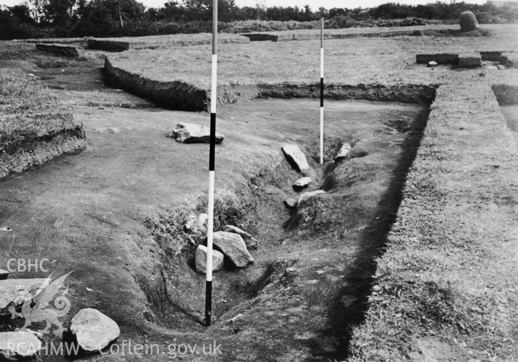
In August 1938, W.F. Grimes was hired to begin excavations at Meini Gwyr “because of its proximity to the source of the Stonehenge ‘bluestones’, with hopes that something may be learned from it of the connection of Stonehenge with south-west Wales.” (Grimes 1939, 373)
Grimes claimed that the report of this site was never fully published because the excavation record had been lost when enemy bombings destroyed the Ordnance Survey Offices at Southampton during the Second World War. We can only imagine what kind of documentation may have been lost..
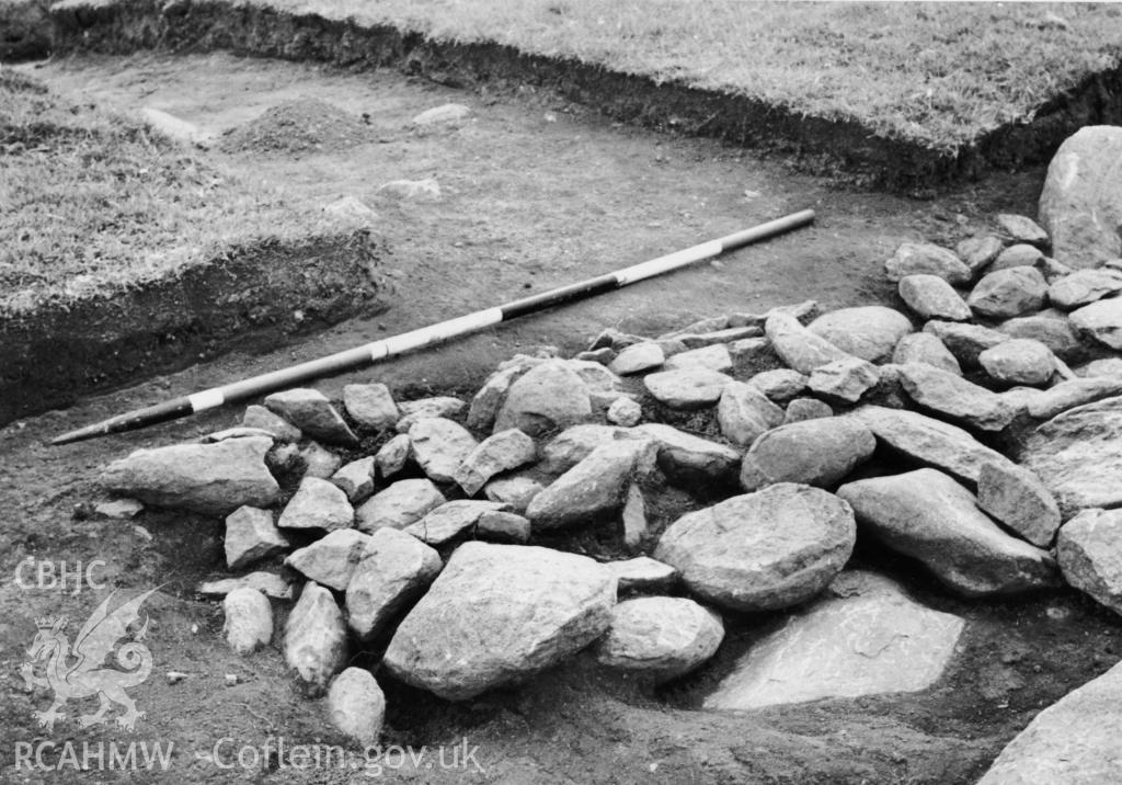
Thankfully some of the notes did survive as well as photographs of the excavation..His excavation established how the outer ‘bank of the site was composed of clay and decayed turf scraped up from the surface, with some stones in the body of it’. (Grimes 1938) He also noted that ‘[quite extensive] parts of this central area examined, were featureless.’ Outside the ‘entrance’ Grimes found a pit containing charcoal. There was also a hearth within the bank from which Food Vessel sherds were recovered, however these sherds were never published.
The following photographs were taken during excavations in 1938, from Coflein.gov.uk:
Here’s a link to an interesting article on the site if you’d like to learn more: https://www.academia.edu/27538607/Meini_Gwyr_in_History_and_Archaeology_2012_pdf
The site is also discussed in Aubrey Burl’s ‘The Stone Circles of Britain, Ireland and Brittany’, in which he shows William Stukeley’s sketch: “Also known as Buarth Arthur, ‘Arthur’s enclosure’, Meini-gwyr, ‘the leaning stones’, an important but despoiled embanked stone circle, was excavated in 1938. Detailed records of the investigation were destroyed during the war.
Within a rubbly bank 120ft (37m) across stood a ring, about 60ft (18m) in diameter, originally of seventeen stones, Edward Lluyd claiming as many as twenty-three, of which only two survive. At the west was a long, stone-lined entrance some 6ft (2m) wide. At its front a pit filled with clay and fine charcoal was discovered. The site may have been desecrated in prehistory. In one stonehole there was a hearth and some Bronze Age food-vessel shards.
In Camden’s Brittania (1695, 628) there is a report that ‘at the distance of about 200 paces from Meini Gwyr, there stand on end three other large, rude stones’. Two are still erect, the third prostrate, at SN 139 266. Known as Yr Allor, ‘The Altar’, they may be the remains of a Cove similar to others at Avebury (82) and Stanton Drew (75).” – https://archive.org/details/stonecirclesofbr0000burl/page/176/mode/2up
Here is the video we made covering Meini Gwyr –

Leave a comment