
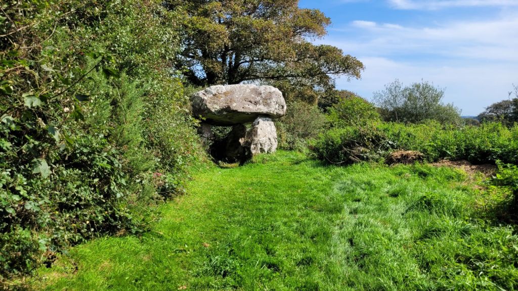
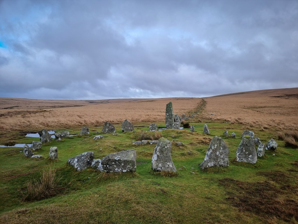
‘The Hanging Stone’ – Neolithic Cromlech in Burton, Pembrokeshire – Wales
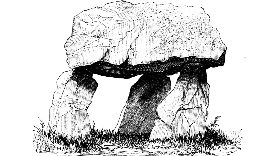
In 1872, British antiquarian Edward Barnwell visited this site and provided illustrations which were drawn by James Tomb and his sister Miss Grace. The following is from the Archaeologia Cambrensis (Fourth Series No. X April 1872):
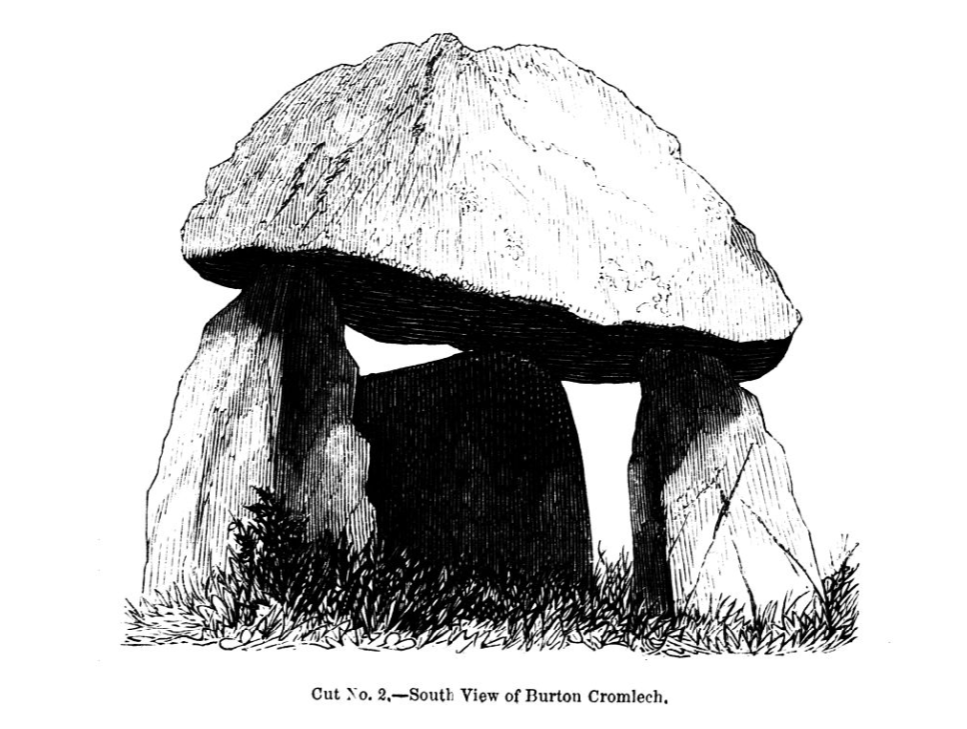
“.. in the parish of Burton, near Haverfordwest, and on the estate of J. H. Scourfield Esq., MP. It was inspected when the Society, in 1864, visited the county under the presidency of that gentleman ; at which time it was built round with loose stones, and used as a small sheep-cot. It has since been cleared out, and is now seen to much better advantage than when visited by the society.
At that time there were some small remains of the original packing of small stones in the interstices between the slabs, – a very unusual occurrence. What was left was but a very small portion, but quite sufficient to give an idea of the firm manner in which this dry rubble-work was worked in.
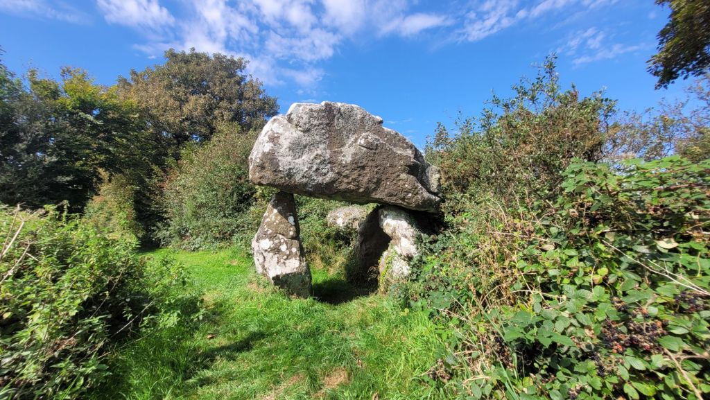
The capstone, from north to south, is 10 ft 2 inches by 8 and a half ft, with a thickness of 4 ft 3inch. From the highest point of the exterior, from the ground is 9 and a half ft. The upright stone on the south side is 6 ft 1 inch ; that on the east side is 5 ft 3 inch; and that on the north side is 5ft 5inch.
The chamber runs nearly north and south, the contrary to the more usual direction of east and west. The Society is indebted to the Rev J Tombs, one of the Local Secretaries for the country, for these measurements and other details.” – https://journals.library.wales/view/2919943/2999961/45#?xywh=-2668%2C-197%2C7514%2C3913
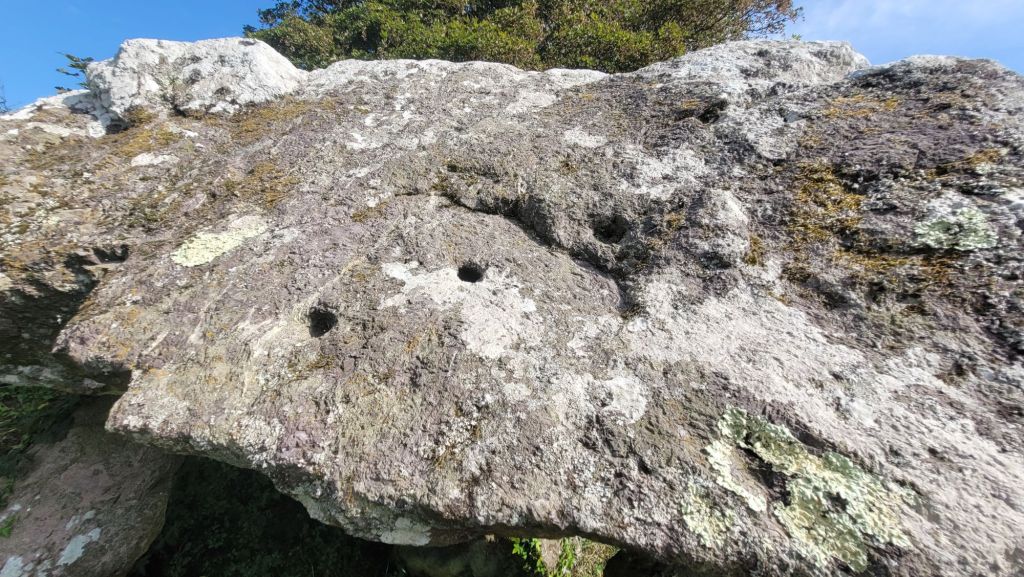
In the 1970s, Professor W. F. Grimes led an excursion to the site and did note the holes on the capstone as ‘possible cup-marks’.
The following is from ‘A reassessment of the neolithic chambered tombs of south-west Wales (Carmarthenshire and Pembrokeshire) by Christopher Thompson Barker (October 1989):
“’The excursionists’ attention was next directed to the mutilated remains of a cromlech, or sepulchral chamber as these monuments are now almost universally allowed to be…a very fair specimen, of moderate dimensions. The structure at present consists of the remains of its supporters (once probably six in number) and a covering stone. A huge mass of rock lies touching part of it, which looks as if it had at one time formed a portion of the gallery or chamber. There are also the remains of original small, dry masonry, by which the gaps between the larger stones were always carefully filled up. Few traces of its former covering, or tumulus, could be made out. A modern bank across the field adjoins one side” (Anon 1864,346-7).
“The capstone, from N to S, is 10ft. 2in by 8[ft 6in] , with a thickness of 4ft 3in [3.1 by 2.6 by 1.3m]…the upright stone on the S side is 6ft lin [1.85m]; that on the E side is 5ft 3in [1.6m]; that on the N side, 5ft 5in [1.65m]” (Barnwell 1872,126]. Two engravings accompany Barnwell’s paper – these show the capstone and the three supporting uprights, but the adjoining bank is omitted. Also omitted is the large adjacent slab; this is next mentioned by the RCAM (1925, 83) – “there is visible a portion of another large stone, which suggests that the original structure was a double cromlech”
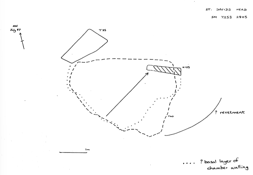
“Grimes (1936a,13) was first to record “the remains of a passage-way to the NE” of the chamber. None of the early accounts mention this, indeed Barnwell was confident that the chamber ran “nearly N and S, the contrary to the more usual direction of E and W” (1872,127). Grimes’ plan of the monument (1936b,131) shoves four uprights beneath the capstone – the fourth being situated between the two supporters on the S side of the chamber. At present a flat slab (0.1m thick) lies here, perhaps no more than a level foundation for dry-stone walling. Traces of just such walling are recorded by Grimes to the E of the N supporter; these survive intact today.
The evidence for the former existence of a passage is confused and somewhat unconvincing. Grimes records an upright to the E of the N supporter, and a companion to this on the opposite ‘side’ adjacent to the SE supporter. While the former is still evident, there is no trace of the latter. But Grimes does not record the solidly-set stone, present today, which appears to continue the N side of the ‘passage’. Lynch (1976, fig 8) does recognize this upright stone, set into the S face of the hedge-bank, and records another stone (not earthfast) on the southern side of the ‘passage’. This last stone has since disappeared. Returning to Grimes’ plan, the large slab (“?displaced capstone”) which lies upon the hedge-bank to the N of the chamber is clearly shown, as is another stone which partially underlies its northern corner. Cultivation of the elevated field to the N has led to the build-up of soil against the hedge-bank, partially obscuring the large slab and completely burying the smaller stone. To the S a low platform (?cairn remnant), radius c.4m, separates the chamber from a regularly ploughed field. Grimes (1936a,13) has classified the monument as a Passage Grave, although Daniel (1950.PEM 24) was less definite. While Lynch (1975,26; 1976,75) prefers to describe it as a small ‘chamber and passage’ tomb, she retains the contacts with the Western sea-ways implied by the concept of the Passage Grave tradition (1975).
Visited November 1986″ – https://theses.gla.ac.uk/78041/1/11007320.pdf
The following is quoted from ‘A guide to ancient and historic Wales. Dyfed’ by Sian E Rees in 1992:
“The polygonal chamber of this tomb is formed by a large capstone supported by three uprights, two in the open field and one in the hedgebank within which part of the site lies incorporated. In the hedge may be seen a large stone which may be a second capstone, and three uprights which some authorities have suggested may be a passage through a surrounding cairn to the chamber. This tomb has accordingly been classified as belonging to the passage grave family along with Carreg Samson. A description of 1864 tells of drystone walling being present between the uprights, but as no such walling remains today, we cannot be sure whether it was likely to have been an original feature or a more modern addition. Nothing visible remains of the surrounding cairn either, though it is conceivable that the hedgebank is protecting parts of a mound.” – https://archive.org/details/guidetoancienthi0000rees/page/28/mode/1up?q=hanging
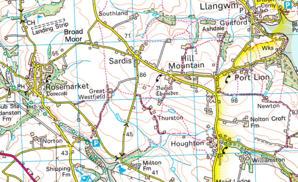
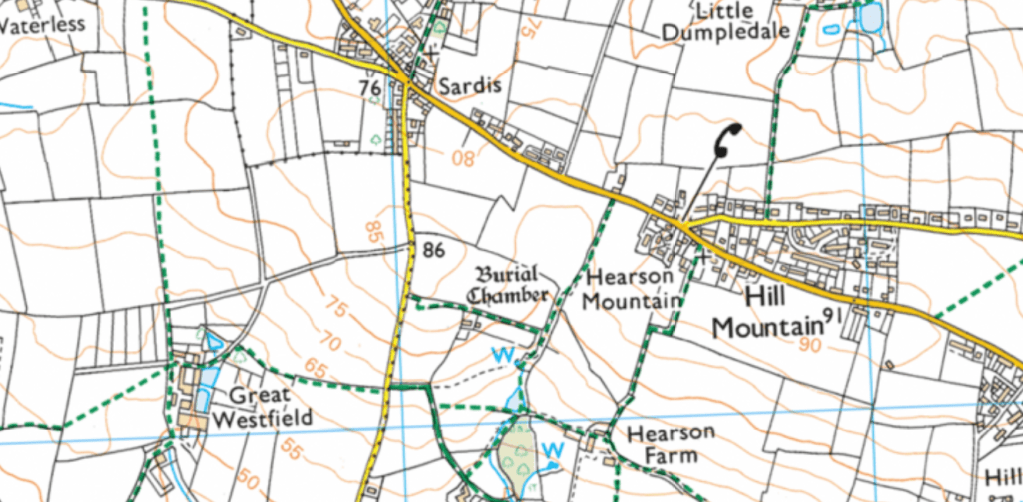
Accessing The Hanging Stone:
This cromlech is on a public footpath which can be accessed from the road. Click the maps below to see the OS maps on Bing.
Here is our video covering The Hanging Stone –

Leave a comment