
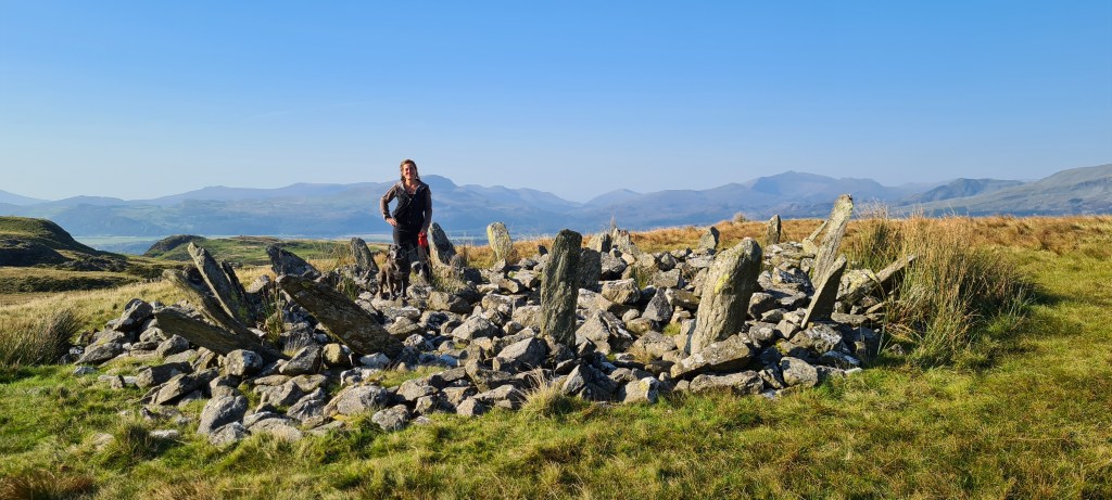
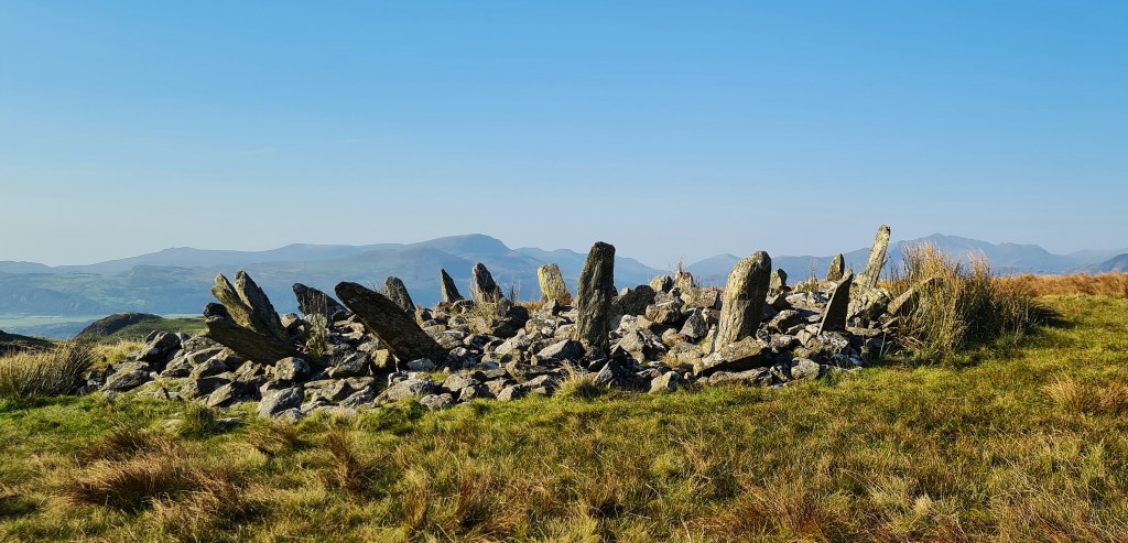
In this post we’ll be exploring the iconic Bronze Age Cairn.. Bryn Cader Faner. This is a stunning monument situated in Eryri (Snowdonia) National Park.. boasting spectacular views of the surrounding mountain landscape. Sadly, the structure has been badly damaged over the years.. From being pillaged by treasure hunters, used as target practice by the army, as well as modern vandalism..
The Structure:
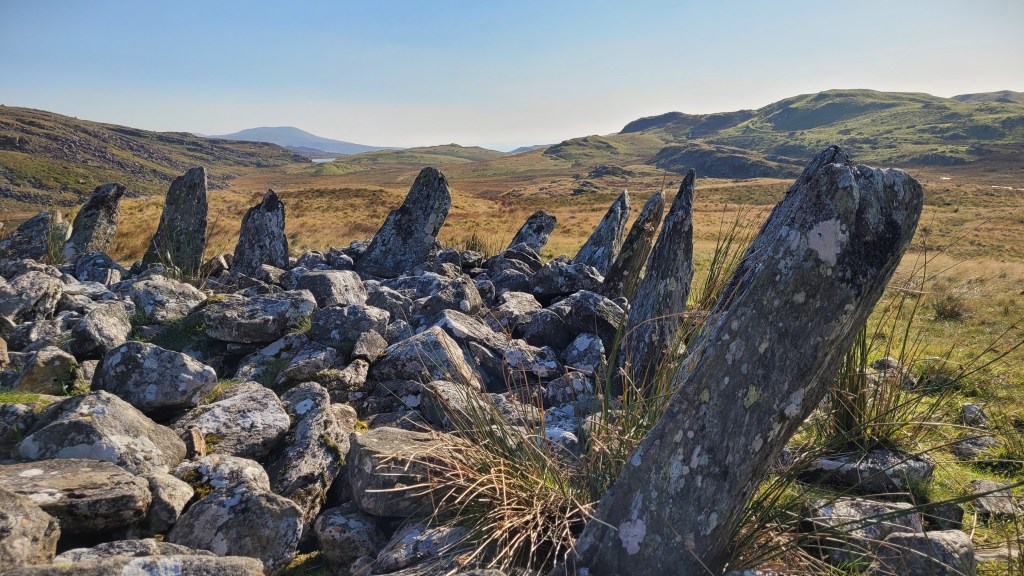
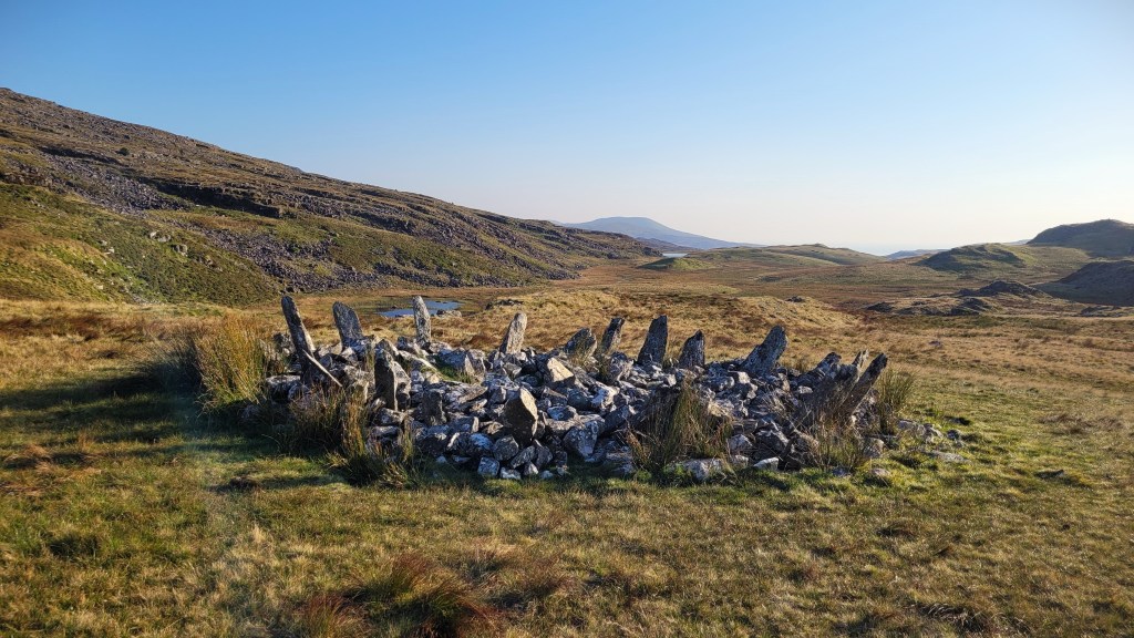
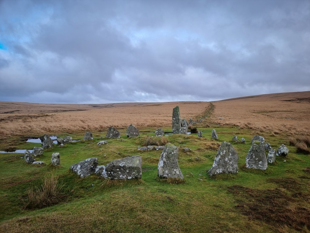
Bryn Cader Faner is made up of a low stone mound, approximately 8 meters in diameter. Around the edge is a ring of tall thin slabs set at an angle, projecting from the mass of the cairn like the rays of the sun.. or perhaps thorns of a crown..
The earliest record we could find was by Edward Llwyd from around the year 1698.. Reprinted in 1910 in the Archaeologia Cambrensis. “Upon Bryn Kader y vaner there is a kist vaen”.
The following is the description on Coflein by Bowen and Gresham 1967: “A small but impressive cairn, situated on a rocky knoll 20 yards south-west of the summit of Bryn Cader Faner. The circumference contains the remains of a peristalith, a ring of upright stones around a mound, consisting of some fifteen stones between 3ft and 4ft high. Round the extreme edge of the mound are the traces of a kerb and in the centre is a rectangular hole dug by treasure-seekers, within which are the remains of the slabs of a destroyed cist (probably the ‘Kist vaen’ on Bryn Cader Faner mentioned around the year 1698 by Llwyd.)” – CADW
Carn Llechart in Neath Port Talbot is a site that is regularly compared with Bryn Cader Faner. A late Neolithic or early Bronze Age circle of some 25 low stones with a shattered stone lined cist toward the centre. The circle of stones are tilted slightly outwards.
It has been suggested that the circle was a kerb to a covering earthen mound.. though no traces of a covering mound exists today. Others suggest that this site and monuments like this represent a mixture of ceremonial purposes at a time of change.. Or changing methods of monument building..
This suggestion of the builders having seen early stone circles, perhaps elsewhere in Wales or further afield and decided to incorporate the idea into their own structures.. producing a sort of hybrid structure, is not an uncommon one. Some suggest that these are a possible ‘hybrid’.

Aubrey Burl, 1976:
In the book ‘The Stone Circles of the British Isles’ written by Aubrey Burl in 1976, he suggests that..
“The existence of stone circles elsewhere impelled people to place tall stones around the bases of their own round cairns, a fusion of traditions resulting in monuments like spiky coronets. Such cairns may be seen on North and South Uist, and in Wales at Carn Llechart, Glamorgan, and Bryn Cader Faner, Merioneth..
..Other writers believed the megalithic circle was a counterpart in stone of the earth or timber circles of lowland Britain. The paucity of dating material prevented them from constructing any typological sequence to substantiate this. Still others looked to those passage-graves of western Britain with surrounding stones or banks or ditches for a possible source. ‘A low mound in Ballyanny townland near Nenagh appears to have a kerb and also a concentric ring of stones outside it. This phenomenom of a ring of stones encircling a burial mound is of interest in relation to the origin of the stone cirlce’(S.P.O’Riordain 1964-90)
But it has to be admitted that any typology of stone circles is at present innately unreliable because there are so few dates on which to construct it. Artefactual material is sparse and unevenly distributed. In the search for beginnings one can look only at various possibilities; that the British stone circles had a foreign origin; that they developed from ritual enclosures; or from passage- graves; or from timber circles; or from the circular embanked areas known as henges…” https://archive.org/details/stonecirclesof00burl/page/20/mode/1up?view=theater&q=bryn+cader+faner
Damage to the site:
Asides from the obvious damage caused by treasure seekers.. The British Army, during manoeuvres before the Second World War, caused heavy damage to the Bryn Cader Faner site. Some report that The Army pulled out stones on the east side to use in gunnery practice. On Coflein, there is a photograph dated between 1920-1950(?) which shows heavy damage to one side and it doesn’t look like there are any stones standing.
Gwynedd Archaeological Trust notes that the site was damaged by the army on manoeuvres in 1939.

This iconic monument, often illustrated for its ‘crown’ like structure, set in a highly visible position in the hills of Merionydd. Frances Lynch, describes the area in her book. From A Guide to Ancient and Historic Wales: Gwynedd’ written by Frances Lynch 1995:
“The county of Gwynedd epitomises the classic idea of Welshness. It was the heart of the last surviving independent principality in Wales, and the Welsh language and cultural traditions in this region have resisted the inroads of English and international uniformity longer than anywhere else in the country. The image of a mountain fastness conjured by the name Eryri (Snowdonia) is appropriate, for much of the region is remote, rocky and sparsely inhabited. However, the glaciated landscapes around the great mountain of Snowdon, so famous in the annals of geology, geomorphology and the Wales Tourist Board, are not characteristic of the whole of the country..
..The high ground of Ardudwy and [southern?] Meirionnydd surrounding Cardigan Bay drops down to a narrow coastal strip into which most modern development is concentrated, but earlier settlement extended to the higher land, leaving an unparalleled record of ancient landscapes surviving virtually intact. Those exploring these hills will encounter monuments, fields and settlements of several different periods.”
The following is from: https://www.prehistoricsociety.org/sites/prehistoricsociety.org/files/resources/ps-signpost_bryn-cader-faner.pdf
‘The area surrounding Bryn Cader Faner is rich in prehistoric remains, several associated with the ancient trackway that runs to the coast. Around 275m SW of Bryn Cader Faner is a small enclosed settlement. It measures about 38m across and has two hut circles, each 4.5 in diameter, set in opposite corners of a courtyard. The walls have been heavily robbed to built the sheepfold that now overlies the site.
Also SW of Bryn Cader Faner is Llyn Eiddew. Only a few stones remain of this ring cairn circle. The remnant of three small cairns lie within the circle and a further larger cairns can be found around 50m to the north. A few hundred meters further south along the track is Llyn Eiddew Bach III. Seven stones now form this ring cairn, one of which has fallen. Burl suggests there may once have been 13 or 14 stones.
On the path descending north west from Bryn Cader Faner are the hut circles of Moel Geifr and a group of cairns below Y Gyrn. The most westerly is 33m in circumfrence. A ring of stones extends for around 2m from the central mounds. As at Bryn Cader Faner, they are set at a 45degree angle, pointing radially outwards. A little further up the stream stands a second cairn, Y Gyrn with two concentric rings; a large collapsed central cist is clearly visible. A slab lying nearby probably once stood upright. A third cairn lies 30m to the NE on the bank of the stream. ‘
Accessing the site:
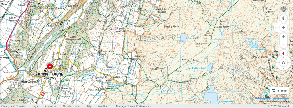
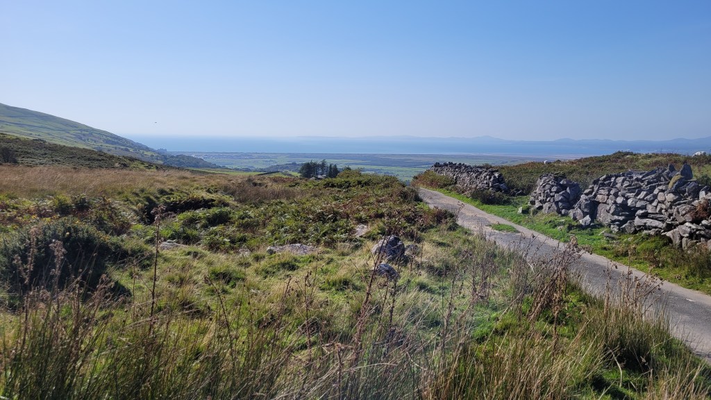
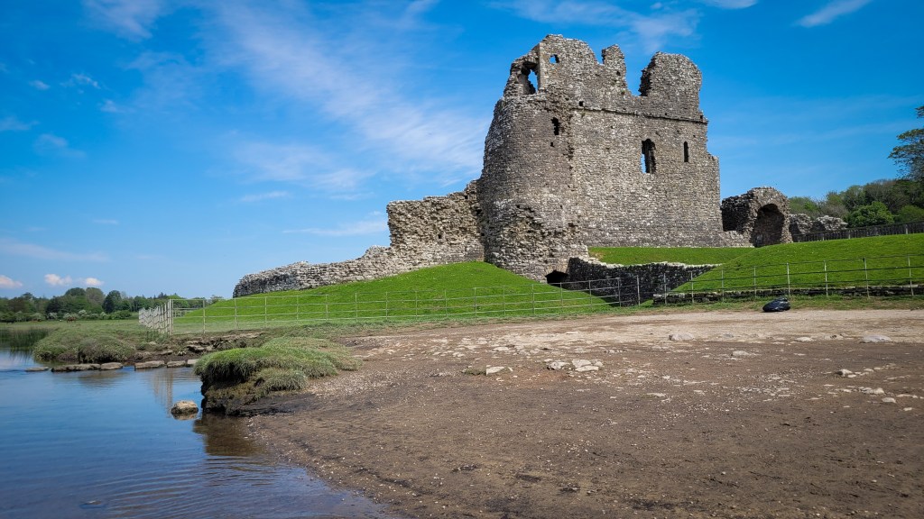
To access Bryn Cader Faner, we parked at the end of a mountain track above Eisingrug, where there is a small parking area with a donations box. The view from here is amazing, with Harlech Castle silhouetted at the coast in the distance..
We go into a lot more detail of the route we took in our video..

Leave a comment