
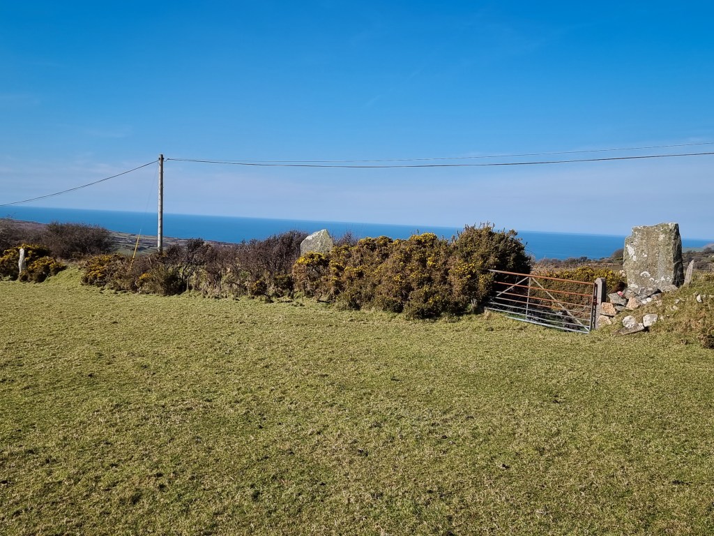
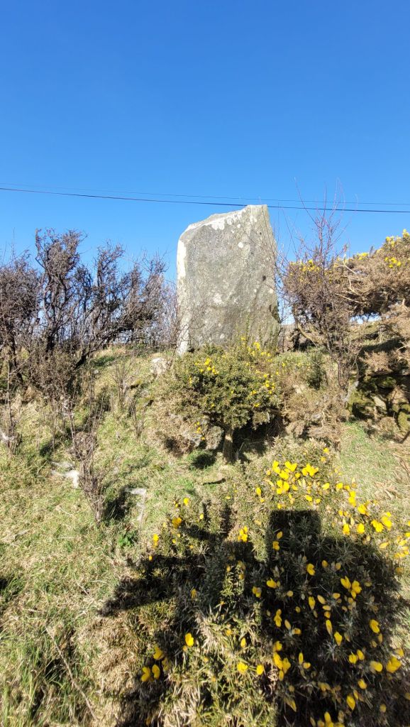
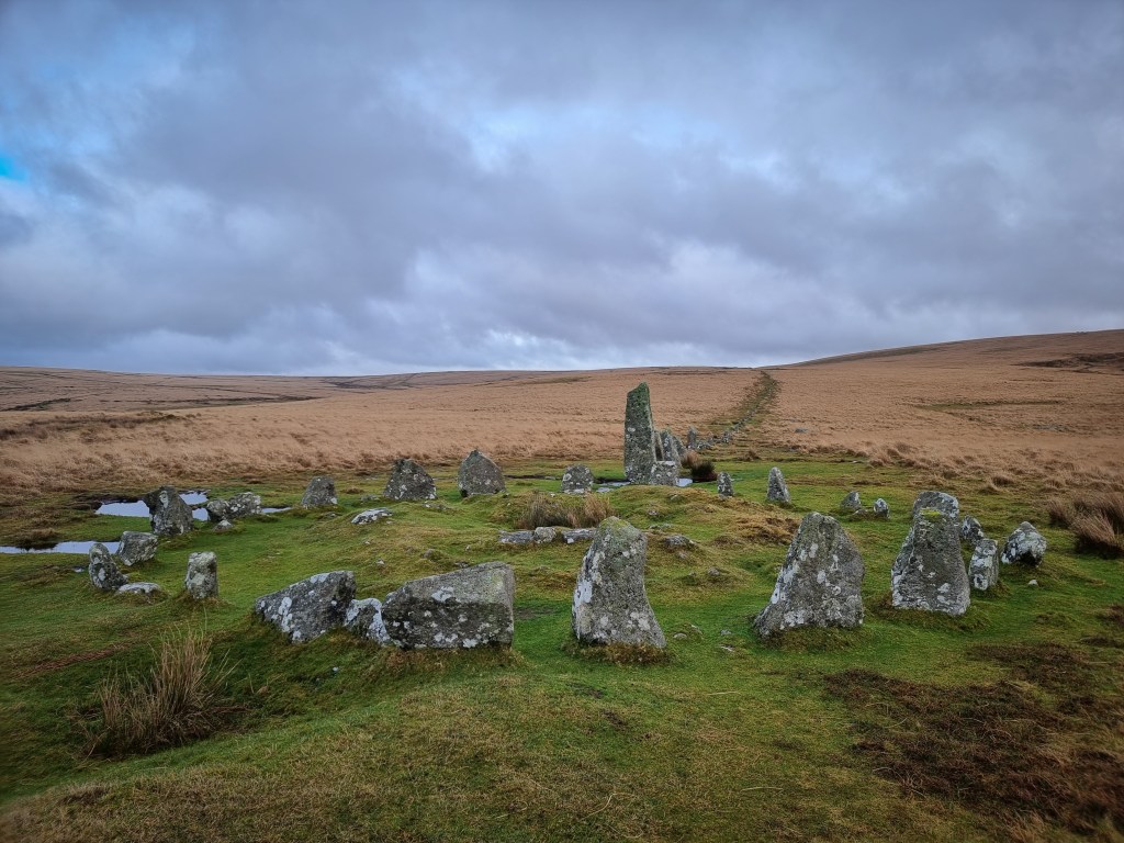
This site in considered to be the longest Bronze Age stone row in Wales. The name translates to Field of the Dead, and is located within the parish of Llanllawer (older-Llanllawern) in Pembrokeshire.
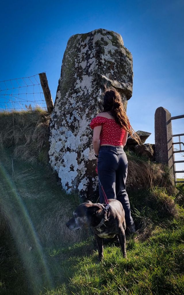
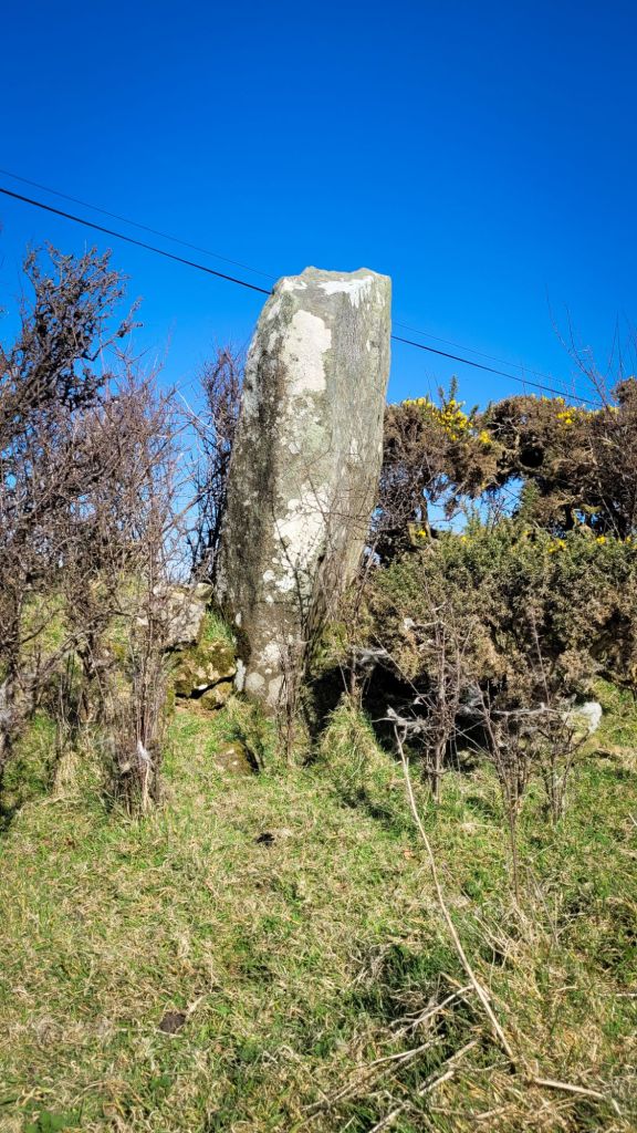
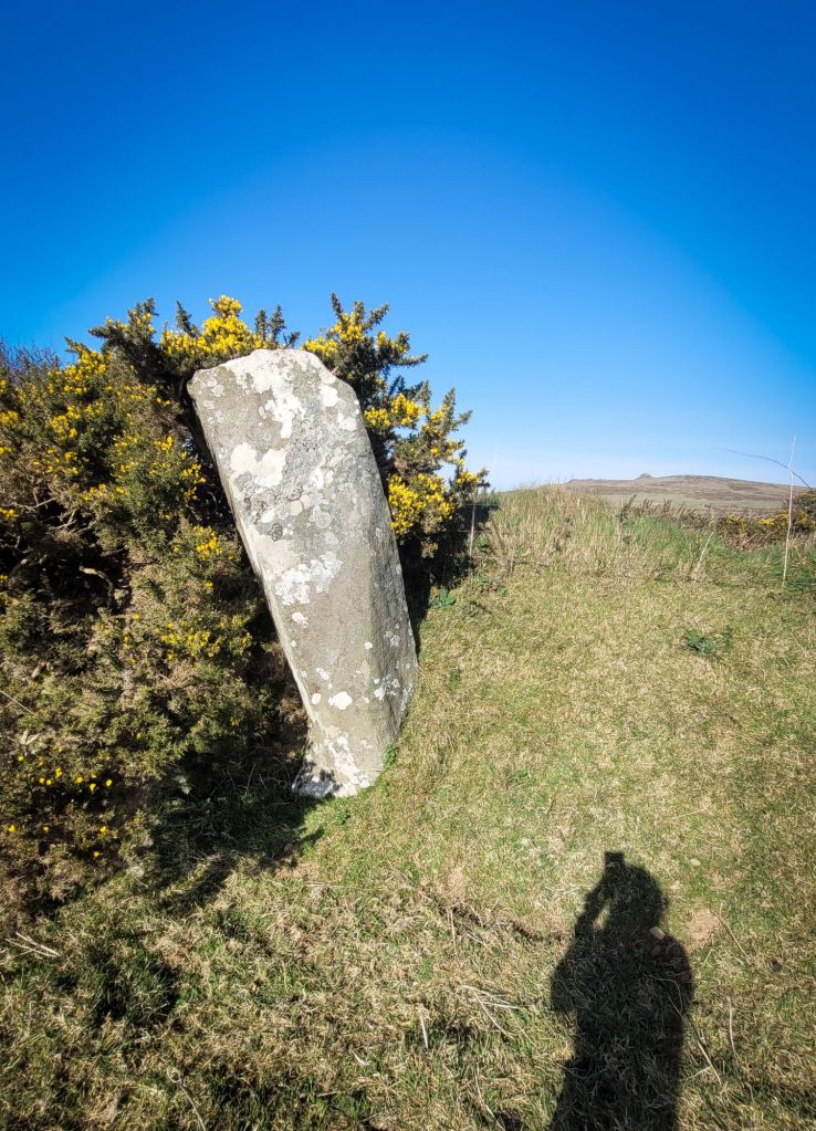
Today, the site consists of four standing stones and two prostrate stones with the tallest 2.7m high. They are set within a 19th century field boundary wall. One of the stones may also have carvings. There is some evidence that is extended at one time as far as Trellwyn farm where old OS maps label a cromlech which is no longer there.. In the fields of Trellwyn-fach and Trellwyn-fawr are also standing stones that were once described as having once been cromlechs.
According to Coflein, eight stones have previously been noted but they provide no further information.
In 1868, Edward Barnwell writes in Archaeologia Cambrensis: “In the northern part of Pembrokeshire is a single line of stones of great size, which Fenton does not mention, although he deliberately pulled to pieces a fine cromlech near it, and which seems to have been connected with this row of stones, for it was probably continued further northwards than it is at present. On referring to the Ordance map, a little to the right of the word “Llanlawer”, will be seen the position of the line called in the map “Parc y marw” (field of the dead); and a little further to the east, but slightly to the north, is marked down the cromlech destroyed by Fenton, and of which only some small fragments remain. The line of stones is parallel to the narrow road, and if continued would pass within a few paces of the ruined cromlech.
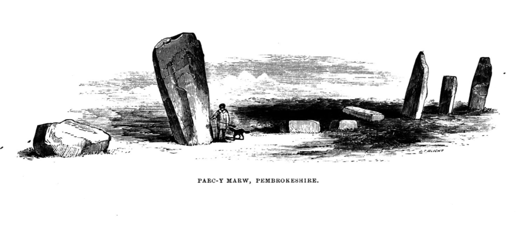
Here, as at Rhos-y-beddau, the name points to the character of the monument ; for experience has shewn that local names of this kind in Wales, handed down from time immemorial, may be generally depended on. Local tradition, however, adds an account of a desperate battle fought on the spot, among the pillar-stones themselves, as if the possession of them were said to have been the sole object of the combatants. A lady, clad all in white, appears to those who are rash enough to walk that way by night ; and so ancient is this tradition, which is still firmly believed, that a short distance before the stones commence, a foot path, by long use now become public, turns across the fields to the left, making a detour of nearly a mile before it leads again into the road. During day-time the peasants do not think it necessary to take the roundabout course. The road itself is evidently one of great antiquity, and apparently led to the great work at Dinas. The height of the stones is not so striking as their lower part is embedded in the tall bank of earth that does the duty of an ordinary hedge ; but some of them are full sixteen feet long. An accurate representation is here given of them, from the skillful pencil of Mr. Blight, taken on the spot in June 1866. One of the stones has fallen across the road ; and on it are incised some curious lines, which are not modern work, and have the appearance of having been cut in the same manner, and by the same means, as other archaic incised work. None of the other stones has any marking at all ; but as they are deeply embedded in the bank, only the upper parts are visible. There were no traces, so that this seems to have always been a single line ; but although single, it must have been a striking object at a time when no enclosures existed, and the present level of the soil lower than it is now. It is hardly necessary to state that in the view the hedge-bank is omitted..”
https://journals.library.wales/view/2919943/2997993/86#?xywh=-506%2C1462%2C3624%2C1887
Writings by Reverend D. C. Jones printed between 1908 and 1909 by The Fishguard and Goodwick County Times.. talks of chambered tomb at Trellwyn fach in Llanllawer which is described in nineteenth-century sources and marked as a ‘Pagan Altar’ on an estate map of 1754.3 He says of it that:
“There was a fine cromlech and stone circle in Trellwynfach’s field until around 35 years ago, when it was removed for building purposes by Mr Job Francis”
– https://www.pembrokeshirehistoricalsociety.co.uk/memories-preserved-antiquities-oral-traditions-dinas-writings-gwynrug-1908-9/
The following is from ‘Parochiale Wallicanum; or, the names of churches, chapels, etc…’ by Arthur Wade-Evans (1911).
“On the Six Inch O.S. Map, Pembrokeshire, Sheet x, N.W. (second edition, 1908), within the parish of Llanllawer (for older Llanllawern), on the right hand side of the road going east from the parish church, and about three-quarters of a mile from the same, is a spot marked “Standing Stones”, these being in the hedge of a field along the road, another field adjoining being called “Parc y Meirw”. These stones are known as ‘y pyst hirion’ and are traditionally said to mark the site of a battle, in which the defeated were driven south over some high rocks, known as Craigynestra, into the river Gwaun. Some of the bodies were carried down by the river to Cwm Abergwaun, or Fishguard Bottom. The folk add no explanation of the name Craigynestra, which may be for Craig lanastra. In the Arch. Camb. for April 1868, in a paper by Mr Barnwell, there is a reference to these stones, which are described as **Barnwells account***..
…A plate, in which the hedge bank is omitted, accompanies Mr Barnwell’s article. The mountain, on the slope of which Parc y Meirw is situated, is known from the southern side as Mynydd Llanllawer, and from the Dinas side as Y Garn Vawr. Under this last name it is mentioned by George Owen (see Owen’s Pembrokeshire, i, 108, ii, 506, where it is wrongly identified in the notes with Trevasser mountain of the same name in Pencaer). From the Fishguard side the mountain resembles a breast with the carn as nipple. The whole, rising a thousand feet above the sea, is very conspicuous from the south and west, the spot where the stones are situated being in full view of Fishguard. From the top may be seen Trevgarn rocks, Ramsey Island, and the country below Haverfordwest. Surrounded by lesser carns such as Carn Sevyll, Carn Blewyn, Carn Madog, etc,, its commanding position fains for it the distinctive name of Y Garn Vawr, the great carn. This spot meets the conditions demanded in Historia hen Gruffud van Kenan vab Yago for the site of the famous Battle of Mynydd Carn (A.D. 1079)..”
– https://archive.org/details/cu31924029444795/page/n41/mode/2up?q=meirw
From ‘Prehistoric astronomy and ritual’ by Aubrey Burl, 1983:
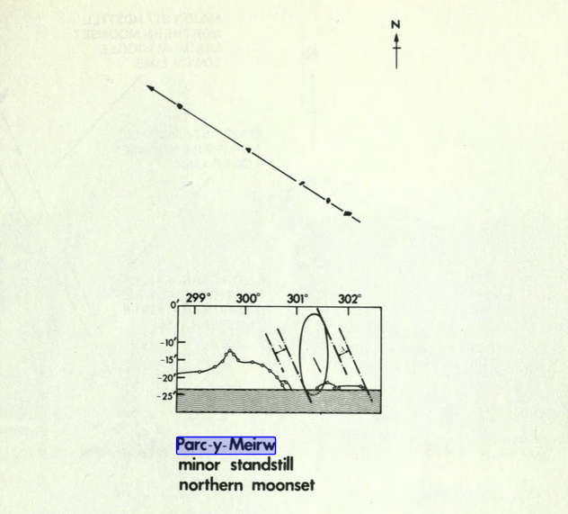
“Parc y Meirw, eight stones in a line 130 feet (40m) long near Fishguard in Dyfed, has been claimed as ‘undoubtedly lunar’ because its axis lies in the direction of the minor northern moonset. For this alignment to work one would have to be able to see a mountainous foresight near Mount Leinster in Eire 91 miles (146km) away, so distant that because of atmospheric refraction it may have never been visible.” – https://archive.org/details/prehistoricastro0000burl/page/38/mode/2up?ref=ol&view=theater&q=meirw
The following is from ‘In Search of Ancient Astronomies’ by Edwin C. Krupp in 1944:
“Parc y Meirw in a noteworthy lunar backsight because the distance to the foresight is so great, ninety one miles. The foresight is not often visible because of poor weather in our modern era. The site consists of four large menhirs and is probably lunar. The ground rises and prohibits observation to the southeast. The minor standstill moonset could have been observed, however, to the northeast. Mount Leinster in Wexford, Ireland, and some surrounding ground is always above the sea horizon and is in the correct lunar orientation. Clear skies would have been reuired to see this foresight silhoutted against the moon. The climate in Britain must have been better in Megalithic times than today. One interested observer indicacted that he had seen the Irish hills from Parc y Meirw on a clear day. Its use as a lunar observatory is therefore quite possible.”
They also provide a drawing:
Here is a link to another book discussing the site as a lunar site – ‘Megalithic sites in Britain’ by Thom, A, 1967 – https://archive.org/details/megalithicsitesi0000thom/page/158/mode/2up?view=theater&q=meirw
Parc a Meirw mentioned in Sacred Stones by Terry John, 1994:
“One of the most famous alignments of stones in West Wales is the row known as Parc y Meirw, near Llanllawern in Pembrokeshire. Here, eight large stones stretched for 40 metres or more along a deep lane leading down a gently sloping hillside. Only four of the stones remain upright today, in the hedge bordering the lane, but even so the row and its setting, overlooking Fishguard Harbour, is impressive. It is easy, in such panoramic surroundings, to appreiate why many people believe that pillars such as these were once used to study the movements of the stars – but do these and other theories contain any truth?”
https://archive.org/details/sacredstonesstan0000john/page/26/mode/2up?view=theater&q=Parc+y+Meirw
From ‘Saints and Stones’ by Damien Walford Davies & Anne Eastham, 2002:
“..These are part of an alignment, other elements of which may still be seen along the banks of either side of the lane. These traces suggest that Parc y Meirw was once a megalithic avenue rather than a single alignment, and there is some evidence that is extended at one time as far as Trellwyn farm. The stones are aligned north-west; a bearing on them extends to the deep water channel to the north of the Tusker rock at the entrance to Wexford harbour in Ireland. This could be coincidence, but it is possible that the alignment was used as a navigation aid by its prehistoric builders.
The field name Parc y Meirw – Field of the Dead – may derive from the battle of Mynydd Carn which is believed to have taken place nearby in 1081 and which is recorded in a contemporary poem by Meilyr Brydydd. During the course of the fighting, three Welsh princes – Trahaearn ap Caradog, Caradog ap Gruffudd, and Meilyr ap Rhiwallon – were killed by the forces of Rhys ap Tewdwr of Deheubarth and Gruffudd ap Cynan, assisted by the Irish. Later that year, William the Conqueror came on expedition or pilgrimage to St Davids, secure in the knowledge that this encounter, which had eliminated so many of the Welsh leaders who might have opposed him, had significantly expedited his Cymro-Norman settlement of south Wales.”
https://archive.org/details/saintsstonesguid0000davi/page/18/mode/2up?q=meirw&view=theater

Leave a comment